In the 1930s, government geologists documented gold across 990 square miles of North Dakota. Every miner who tried to extract it went broke. The gold was too deep, too fine, and trapped in water-saturated sediments.
This isn't exploration. It's completion.
In 1934, FERA geologists sampled 5,000+ locations across North Dakota and confirmed gold across 990 square miles. Concentrated pannings assayed up to 0.56 oz/ton. The researchers recommended "thorough prospecting" of the river valleys.
Then funding ended. The Great Depression deepened. World War II intervened. The investigation was never completed. For 90 years, that recommendation sat in government archives.
Every conventional attempt failed for the same reasons: the gold sits 70-250 feet deep in water-saturated glacial sediments. You can't dig an open pit through that. You can't pump it dry. You can't sluice flour-fine gold that washes away with the sand.
Our technology doesn't fight those conditions. It uses them.
The 1930s miners couldn't reach 70+ feet through water-saturated sediments. Modern Bakken oilfield methods can. We've adapted horizontal drilling, pneumatic fracturing, and closed-loop fluid systems to create subsurface gravity concentrators that process material in place.
Wells are drilled into the low-permeability confining layer beneath the mineral-bearing zone. Pneumatic fracturing using compressed air, nitrogen, or steam creates a network of channels with apertures sized to admit heavy mineral grains while excluding larger material. Where fractures intersect boulder zones, the larger clasts bridge across openings to form natural riffles and flow constrictions.
Steam injection thermally alters clay minerals at fracture surfaces, causing them to stiffen and resist closure. The result is a permanent, self-supporting drainage infrastructure within the confining layer. Proppants can be added where needed to maintain aperture under formation stress.
The system operates in repeated cycles. During mobilization phases, hydraulic injection, mechanical vibration, thermal cycling, and electrokinetic treatment loosen the sediments and reduce grain-to-grain friction. During settling phases, energy input stops and heavy minerals (SG >4) migrate downward under gravity into the drainage network while lighter material remains in place.
When sufficient heavy minerals accumulate in the drainage network, pumps withdraw an enriched slurry through the collection wells. Surface processing handles a fraction of the material volume that conventional mining would require. Process water is clarified and recirculated in a closed loop. Cycles repeat until the target zone is depleted.
Deposits at 70-250 feet that killed conventional economics become viable. We reach depths that aren't feasible with open pit, dredging, or underground methods.
Water-saturated sediments, flour-fine gold, unconsolidated material. The conditions that bankrupted 1930s operations are exactly what our system needs to work.
A 10×10 ft well pad. No massive excavation. No tailings ponds. Operations can co-exist with agriculture, which is critical for working across private land.
Deep glacial placers exist across Alaska, Canada, Scandinavia, and Siberia. The same technology that unlocks North Dakota opens deposits worldwide.
Interactive animation showing the full extraction process: well construction, cyclic mobilization, gravity separation, and concentrate recovery.
View Animation →In 1935, federal investigators documented gold across 400,000+ acres of North Dakota river valleys and recommended "thorough prospecting." Then funding ended. The Depression deepened. The work was never completed.
The 1930s researchers weren't wrong. They were technologically locked out of the real prize.
"The negative findings applied only to the flat lake bed. The original researchers explicitly recommended that the river valleys be 'prospected thoroughly.' That recommendation sat in government archives for 90 years."
Glacial transport from the Canadian Shield created a polymetallic system with critical minerals implications.
Multiple calculation approaches suggest substantial resource potential.
Gold equivalent. Validation requires systematic drilling.
See Full Methodology →Provisional patent covering in-situ extraction methodology for unconsolidated mineral-bearing sediments. Filed November 18, 2025.
Patent PendingFederal geological survey of the Souris River region documenting glacial geology and mineral occurrences.
USGS Publications →1933-1939 Federal Emergency Relief Administration mining operations documentation across North Dakota.
Download PDF →Core samples, heavy mineral analyses, and geological mapping from the Wilson M. Laird Core and Sample Library.
NDGS Website →Visual demonstration of the in-situ extraction process showing well construction, cyclic mobilization, and concentrate recovery.
View Animation →Analysis of the 90-year oversight in the historical record, glacial transport mechanics, and the case for completing the 1930s investigation.
Download PDF →
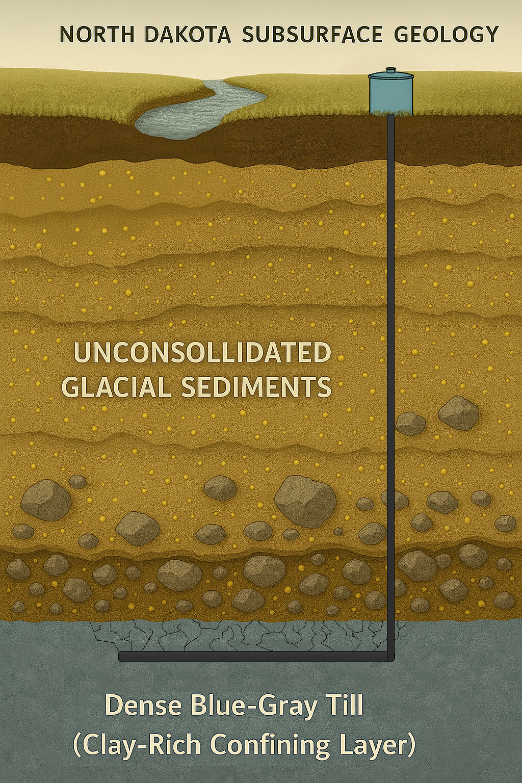
In 1931, the discovery of gold nuggets in the Souris River Valley sparked a brief, frantic rush. But the geology of North Dakota proved to be a formidable gatekeeper: the gold was too deep, too fine, and trapped in water-saturated sediments that bankrupted every conventional mining operation of the era. By 1935, federal investigations by the FERA and USGS were halted, leaving the state's most promising mineral corridors documented but untouched.
Lost Horizon Inc. was founded to finish that investigation. By applying advanced hydraulic and drilling methodologies perfected in the Bakken oil fields to the specific challenges of deep glacial placers, we have bridged the gap between historical geological data and modern extraction capability. We don't see the 80-foot overburden as a barrier. We see it as a pressurized environment where our proprietary technology thrives.
Our thesis is supported by more than archives. In the heart of the gold-bearing valley in Carpio, ND, modern surface sampling has identified over 70 gold-bearing specimens and quartz vein material consistent with Canadian Shield origin. The glacial transport system is no longer a geological theory. It is a massive, untapped resource finally within reach.
Founder & CEO
BBA Finance, Concordia University St. Paul Carpio, North DakotaThe extraction methodology applies to similar geological settings worldwide. North Dakota is the primary target; the technology has global applicability.
100+ million oz historical glacial gold estimates in Nome and interior regions. Similar glacial transport geology.
Extensive glacial placer systems across the Canadian Shield margin. Direct transport path from source districts.
Rare earth element deposits in unconsolidated coastal sediments. High strategic value for domestic supply chain.
Similar Pleistocene glaciation history. Documented heavy mineral occurrences in glacial sediments.
We're interested in discussing technology licensing, joint ventures, and strategic partnerships with established mining operations.